
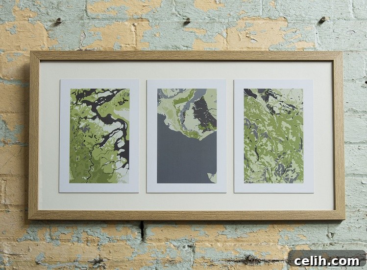
Art Maps: Unearthing Natural Beauty in Historic Geological Maps
Every once in a while, a truly unique business emerges from an unexpected legacy, transforming forgotten historical artifacts into captivating works of art. Such is the inspiring story of Art Maps, a captivating venture founded by Dale Woods. What began as an extraordinary inheritance – hundreds of historical maps meticulously amassed by his wife’s uncle, John, throughout his lifetime – gradually evolved into a thriving enterprise offering distinctive and unique geological art map prints. These maps, spanning the entire UK and beyond, presented Dale with a treasure trove of visual, historical, and geographical fascination. However, they also posed a considerable logistical challenge due to their sheer volume and bulk. In this exclusive feature, Sara Walker delves into Dale’s remarkable journey, exploring how he ingeniously transformed this unusual legacy into a creative and commercially successful business.
Art Maps stands as a testament to the idea that profound artistry can be found in the most unexpected places. Dale’s unique vision was to reveal the inherent beauty and intricate patterns hidden within these century-old cartographic documents, specifically focusing on historical geological surveys. Unlike traditional maps that often depict human modifications to the landscape – cities, roads, and national borders – geological maps unveil the raw, untamed forces of nature. They illustrate the ancient dance of tectonic plates, the slow grind of erosion, the dramatic impact of fault lines, and the intricate patterns laid down over millions of years by geological processes. This profound commitment to showcasing the Earth’s natural artistry is what truly sets Art Maps apart. It offers collectors, interior designers, and art enthusiasts a stunning window into the planet’s deep history, beautifully rendered for modern living and working spaces, providing unique wall art that sparks conversation and contemplation.
Beyond simply selling prints, Art Maps is dedicated to a broader mission: preserving history, celebrating the art of cartography, and bringing a fresh, artistic perspective to scientific data. Each print from Art Maps is a carefully curated piece, transforming a segment of a larger historical document into a vibrant work of art. This transformation is achieved with meticulous attention to detail and a profound respect for the original material’s integrity. The entire process involves not only a keen artistic eye to discern aesthetic potential but also a fundamental understanding of the geological narratives embedded within the maps. It’s a fascinating journey from forgotten archive to compelling artwork, making the invisible geological processes visible and transforming complex scientific data into evocative, museum-quality visual experiences that enrich any environment.
An Exclusive Interview with Dale Woods: The Journey from Cartographic Hoard to Unique Artistry with Art Maps
SW: I love the fact that there’s such a strong family link with the maps. Were the original maps of lots of different types, for example, Ordnance Survey, aviation, geological? Why did you pick out the geological ones to work with for Art Maps?
DW: The family connection is, without a doubt, at the very heart of Art Maps, and it’s a personal story that I genuinely love sharing. John, my wife’s uncle, was an incredibly passionate and dedicated collector, and his lifelong enthusiasm truly shone through in the sheer variety and volume of maps he meticulously accumulated. To answer your question directly, yes, the original collection was incredibly diverse. We were fortunate to inherit historical Ordnance Survey maps dating back to the 1940s, 50s, and 60s, showcasing various editions and revisions that offer fascinating glimpses into Britain’s evolving landscape. One particular favorite of mine is a 1959 Manchester map, famously ‘revised in 1964 with major new roads added’ – that ‘new road’ being none other than the M62 motorway, a significant piece of British infrastructure history captured in cartographic form. The collection also includes a substantial number of Bartholomew’s maps, beautifully printed on cloth and originally priced at six shillings each, alongside a complete set of the iconic Landranger series. Beyond these, there are many other intriguing pieces, including a fascinating map of British airspace dating back to the 1960s, which is a true snapshot of aviation history.
However, when it came to making the critical decision of which maps to specifically transform into art for the Art Maps brand, I overwhelmingly gravitated towards the geological survey maps. My decision was primarily driven by the profoundly captivating lines and shapes inherent in these maps – elements that are entirely natural, having been forged by millennia of geological processes. Other map types, such as Ordnance Survey or aviation charts, primarily depict the Earth’s surface as it has been shaped and modified by human activity over the last couple of thousand years. They illustrate towns, roads, flight paths, and political boundaries – all products of human endeavor and intervention. In stark contrast, geological maps are untouched by human influence. The intricate patterns, the swirling strata of different rock types, the sharp, dramatic fault lines, and the subtle variations we observe on these maps are the direct result of colossal forces acting over millions of years. They offer a direct, unfiltered visual representation of the planet’s ancient, raw geology. This prehistoric artistry, unaffected by human beings, resonated deeply with my aesthetic sensibilities, and I firmly believed it possessed an unparalleled beauty simply waiting to be revealed and appreciated as unique geological wall art.
SW: Do you have any idea how many maps you originally inherited? Was your initial reaction “Oh, fantastic!” or “Oh, dear!” when you first encountered them?
DW: Estimating the exact number of maps initially inherited is quite challenging, but I can tell you unequivocally that the collection was substantial. We have well over a hundred geological maps alone, which are currently the primary focus for Art Maps, along with another couple of hundred of the other types I mentioned, such as the historical Ordnance Survey maps and the beautiful Bartholomew’s editions. So, when you total it up, we’re talking about several hundred maps in total, each one a fascinating piece of history and a potential source of unique artwork.
As for our initial reaction to this rather formidable inheritance, to be perfectly honest, it was a complex and immediate mix of both ‘Oh, fantastic!’ and ‘Oh, dear, good grief!’ simultaneously. While the maps were indeed endlessly fascinating and visually rich, a treasure trove for anyone interested in cartography or history, they actually represented the smallest part of the entire inheritance we received. The vast majority of Uncle John’s house was absolutely packed, floor to ceiling, with books – thousands upon thousands of them. This incredible, sprawling library included a superb selection of geological and geographical texts, which, serendipitously, proved to be highly relevant to my eventual path with Art Maps. However, Uncle John’s interests were incredibly eclectic and far-reaching. He was also deeply passionate about chess, chemistry, science fiction (with a particular fondness for the novels of Nevil Shute), and Russian Romanov history. Imagine an entire house filled to the brim with these diverse and extensive collections! Getting everything into any sort of logical order, and frankly, just figuring out where to put it all while respecting his legacy, has been an ongoing and significant challenge. The maps, while a lovely problem to have, were just one fascinating facet of a truly overwhelming, yet ultimately rewarding, inheritance that sparked the creation of Art Maps.
SW: Picking individual maps out of so many to work with seems like a bit of a Herculean task. What criteria did you apply for selecting the best candidates for Art Maps?
DW: You’ve certainly hit on a very good point; the selection process was indeed quite a Herculean task, as you aptly describe it. With such an extensive collection of geological maps at hand, deciding which specific sections held the most artistic potential for Art Maps was genuinely difficult and required a very specific aesthetic and geological understanding. It wasn’t simply about choosing the ‘prettiest’ map, but rather identifying the most visually dynamic and geologically complex ones.
In the end, my primary criterion was to select those maps, or more accurately, specific sections within larger maps, that appeared to have the most ‘going on’ visually and geologically. By ‘most going on,’ I mean sections that exhibited a rich and intricate geological narrative. This often translated to areas where rocks from a multitude of different geological periods were densely muddled together, creating incredibly intricate, interwoven patterns of color and texture that tell a story of immense planetary activity. I was also keenly interested in examples where the underlying geology had been significantly affected by powerful natural forces such as erosion, evident through dramatic river valleys, winding coastlines, or striking upland features. Equally compelling were prominent fault lines that slice across the landscape, indicating past seismic activity and creating stark visual divisions and fascinating linear elements. In essence, I actively sought out dynamic environments where the immense and relentless forces of pressure, uplift, subsidence, or the ceaseless action of wind and water had thoroughly ‘muddled things up,’ resulting in visually complex, compelling, and often abstract formations. These areas are not only geologically fascinating but also possess an inherent organic artistry that I believe makes for truly unique and powerful wall art prints under the Art Maps brand, offering a glimpse into millions of years of Earth’s history.
SW: Could you talk me through the process from original map to finished print? How much do you do to the original, and how do you do it to create an Art Maps print?
DW: The process of transforming a historical geological map into a contemporary Art Maps print is a meticulous, multi-step journey, skillfully blending traditional appreciation for cartography with cutting-edge modern digital techniques. The original geological survey maps are, by their very nature, produced on a very large scale, often covering vast geographical areas. Therefore, the crucial first decision is to identify and select the specific part of the map that holds the most artistic potential and geological intrigue. This involves careful study of the map, looking for those ‘dynamic’ sections we discussed earlier – areas with complex geological formations, pronounced fault lines, or compelling erosional patterns. This initial selection is akin to cropping a photograph, but with a trained geological and artistic eye, seeking out the perfect composition.
Once an ideal section is chosen, the next critical step is to capture it in extremely high resolution. This is absolutely vital to ensure that every intricate detail, every subtle line, and every unique color variation from the original map is perfectly preserved when the image is ultimately enlarged for fine art printing. After capturing the digital image, the real “restoration” and artistic enhancement work begins. The original maps, being historical documents, are often laden with what I affectionately call ‘man-made surface chatter’ – annotations, grid lines, place names, symbols for roads, railways, and other elements that, while historically significant for navigation or survey purposes, ultimately distract from the pure geological forms when viewed as art. My task then is to meticulously and digitally remove these overlays. A good analogy for this process would be the painstaking restoration of an old master painting. Over decades, layers of grime, discolored varnish, and even previous, less careful restorations can accumulate, obscuring the artist’s original vision. Similarly, I carefully clean away the clutter and ‘dirt’ – both literal imperfections and figurative distractions – from the map’s digital surface to uncover the beautiful, underlying geological picture. This digital cleaning process is incredibly time-consuming and demands extreme precision, requiring a keen eye to differentiate between human-made marks and the truly natural geological features.
It’s incredibly important for me to emphasize this point: I never, under any circumstances, change any of the fundamental shapes or lines of the actual geology depicted. What you ultimately see in a finished Art Maps print is an authentic representation of what lies beneath the ground at the specific site depicted on the original map. My work is not about creating new geology; it’s entirely about revealing, enhancing, and celebrating the existing, natural artistry that has been hidden. However, I do thoughtfully adjust and enhance the colors. The original maps often utilize muted or standardized color palettes that, while scientifically accurate, don’t always fully express the visual drama inherent in the geology. By subtly changing and enriching these colors, I make the exposed geological forms easier to discern and highlight the contrast between different strata more obviously. This enhancement helps to bring the ancient geological narrative vibrantly to life, making the intricate details pop and ensuring that the artwork resonates with a contemporary aesthetic while remaining absolutely true to its scientific origins. Each Art Maps print is a perfect blend of historical accuracy and modern artistic interpretation, meticulously designed to celebrate the Earth’s hidden beauty as unique wall art.
SW: I think this is a new venture for you – what were you doing before? Did you need to learn any new skills for Art Maps?
DW: You are absolutely right; Art Maps is a completely new venture for me, representing a significant career pivot and a leap into an entirely different world. Before embarking on this artistic and entrepreneurial journey, I spent many years running a company that specialized in selling and hiring industrial lifting equipment and machinery. It was a very ‘physical’ business, deeply rooted in hands-on operations, logistics, heavy machinery, and direct client interactions. The transition from that robust industrial world to a predominantly online, creative business like Art Maps has been nothing short of a paradigm shift, requiring me to shed old hats and embrace entirely new ones.
The learning curve has been incredibly steep, particularly when it comes to the digital and marketing aspects of running an online business. One of the biggest challenges, and perhaps the steepest learning curve of all, has been navigating the complex and ever-evolving world of social media and establishing a strong online presence. In my previous professional life, social media was something my children engaged with – a completely alien concept to my business operations, which relied on traditional sales and networking. I initially approached Art Maps with a somewhat naive perspective: I genuinely thought I would simply create beautiful art from these geological maps, and people would either inherently like it or not, and then decide to buy it or not. I truly believed the artwork would speak for itself, relying solely on its intrinsic quality.
What I quickly learned, through a fair bit of trial and error and a lot of late-night reading, is that in the modern digital age, having an exceptional product is only half the battle. You absolutely need to tell people about it! You have to actively engage, explain your unique vision, communicate the story behind Art Maps, and make your products easily discoverable online so that prospective customers can find you and truly understand the unique artistic endeavor and the passion behind what you’re trying to do. Otherwise, as I soon realized, it risks becoming merely a ‘vanity project’ – something beautiful and fulfilling personally, but one that only gets seen by family and close friends, failing to reach a wider audience. In hindsight, this revelation may seem blindingly obvious to many, especially those well-versed in digital marketing, but it certainly took me a little while to fully grasp and integrate into the business model. It’s been a continuous process of learning, adapting, and growing, embracing new skills I never imagined I’d need, all to bring Art Maps to life.
SW: How has the artwork been received so far by the public and art community?
DW: The reception to the Art Maps artwork has been overwhelmingly positive, and honestly, far beyond my initial expectations when I first started this venture. It’s been incredibly gratifying and validating to see how these unique geological prints resonate with such a diverse and appreciative audience. We’ve had a tremendous amount of interest from individuals who are simply looking for distinctive and meaningful pieces to adorn their homes, to professional interior designers seeking bespoke artwork that offers both exceptional aesthetic appeal and a compelling story. The appreciation extends strongly to art collectors who value the unique blend of history, science, and artistry that Art Maps offers, finding genuine merit in the transformation of cartography into fine art. Perhaps most validating of all, we’ve received wonderful feedback from geologists themselves who recognize and appreciate the scientific accuracy married with artistic vision in each print. It’s truly wonderful to know that the prints are seen not just as beautiful objects, but also as celebrations of geological science and the Earth’s intricate history.
What has been particularly exciting and surprising is that the interest isn’t confined to the UK, which is where the original historical maps originate. Art Maps has received contact, inquiries, and orders from people all over the world. This global reach truly underscores the universal appeal of both art and the natural wonders of our planet. It’s a testament to the fact that the inherent beauty of geological formations, when presented artistically, transcends cultural and geographical boundaries. Seeing people from different corners of the globe connect with these pieces, whether for their artistic merit, their historical significance, or their scientific foundation, has been one of the most rewarding aspects of this entire journey. It reinforces my belief that these historical maps hold a profound, hidden beauty that is waiting to be shared with a much wider, international audience, bringing the deep time of Earth into modern spaces.
SW: What’s next for the Art Maps range? Do you have any plans to do anything other than wall prints, for example, fabrics or phone cases?
DW: The future for the Art Maps range is definitely something I’m actively exploring and very excited about. Currently, a significant portion of my time and creative energy is dedicated to working on some truly spectacular larger maps. My vision is for these pieces to translate into even more fantastic and impactful wall art when produced on a grander scale. There’s a considerable amount of meticulous work involved in preparing these large-scale prints, from the initial high-resolution capture of the map sections to the intricate digital cleaning and precise color enhancements, but the potential for dramatic visual impact is immense. I’m quite enthusiastic about these developments and believe they will offer an even more immersive and impressive experience for anyone engaging with the rich geological narratives embedded within them.
Regarding expanding Art Maps beyond traditional wall prints, it’s a question that frequently comes up, and I have certainly given it a lot of thought. The idea of translating these unique geological patterns onto other mediums is very appealing from a creative perspective. I’ve mused about possibilities like elegant table mats for dining, intricate greeting cards for special occasions, or even the exciting prospect of fabrics – imagine the unique patterns of ancient earth adorning textiles for fashion or home decor! I did, for a brief period, consider t-shirts, exploring how the designs might translate onto wearable art, but ultimately decided against it for now. While the concept of diversifying into various product categories like fabrics or phone cases holds intriguing potential, my current focus for Art Maps remains steadfastly on developing and perfecting our core wall art collection. I firmly believe there’s still so much untapped potential within the realm of high-quality fine art prints derived from these remarkable historical maps. For now, I want to continue refining the craftsmanship, expanding the range of available geological locations, and exploring new artistic interpretations within the medium of wall art. This dedicated focus allows me to maintain a consistently high standard of quality and ensures that each Art Maps piece truly stands out as a unique, meaningful, and enduring artwork.
SW: What do you think John, your wife’s uncle, would have made of Art Maps and this new venture?
DW: That’s a wonderful question, and one I’ve pondered quite a bit since starting Art Maps. I genuinely believe John would have found the entire venture quite amusing, but in the best possible way. He had a keen intellect, a dry wit, and a profound appreciation for curiosity, and the idea of his vast collection of old maps being transformed into modern, unique art would certainly have tickled his sense of humor and intellectual curiosity. More importantly, however, I am absolutely certain he would have genuinely loved the art itself. John appreciated beauty and intellectual discovery, and these prints combine both history and science in a visually compelling way that I think would have deeply resonated with him.
I know, without a shadow of a doubt, that he would be incredibly pleased that his cherished collection of maps is not gathering dust in a forgotten map chest, or even worse, being discarded. For any dedicated collector, the thought of one’s prized possessions being neglected, lost, or thrown away is probably one of the greatest concerns. The fact that his legacy, his passion for cartography and geology, is being honored, preserved, and given a vibrant new life through Art Maps, bringing joy and aesthetic pleasure to people in a completely novel way, would fill him with immense satisfaction. It’s not just about the business; it’s about respecting his passion for discovery and ensuring these historical documents continue to inspire and educate new generations. His spirit of discovery and his appreciation for the world’s intricate details and geological wonders live on through every Art Maps print, and that, I believe, would be his greatest pleasure and a lasting tribute to his memory.
To explore the full collection of unique geological art map prints and to purchase online, please visit www.art-maps.co.uk. Prices for these exceptional pieces, offering a window into Earth’s ancient beauty, start at just £20, providing an accessible entry point into the captivating world of historical map art and geological beauty.
All images (c) 2019 Art Maps